BOGOTA — More than two hundred people are confirmed dead after Monday’s magnitude 7.4 earthquake in western Colombia, and rescue teams have still not reached the district where it began.
The Colombia earthquake struck at 7.34 am local time on 10 August, with its epicentre at San Jose del Palmar in the department of Choco, about 240 kilometres west of Bogota. The Colombian Geological Service has called it the country’s strongest quake this century. A CNN count based on reports from national agencies put the death toll at 224 on Tuesday, up from 111 on Monday evening.
Almost all of those confirmed deaths are in cities well away from the epicentre. That is not because Choco escaped. It is because nobody can get in.
The poorest department, and the least reachable
San Jose del Palmar is a municipality of about 4,800 people in dense jungle. Much of Choco is accessible only by boat or light aircraft. It is Colombia’s poorest department, with more than two-thirds of the population living in poverty according to government statistics.
Choco’s governor, Nubia Carolina Cordoba-Curi, reported nine dead and eighty injured in the department and warned that the mountainous terrain around the epicentre would complicate rescue work. Her figures are almost certainly a floor rather than a total, and she has said her government is still preparing an official report.
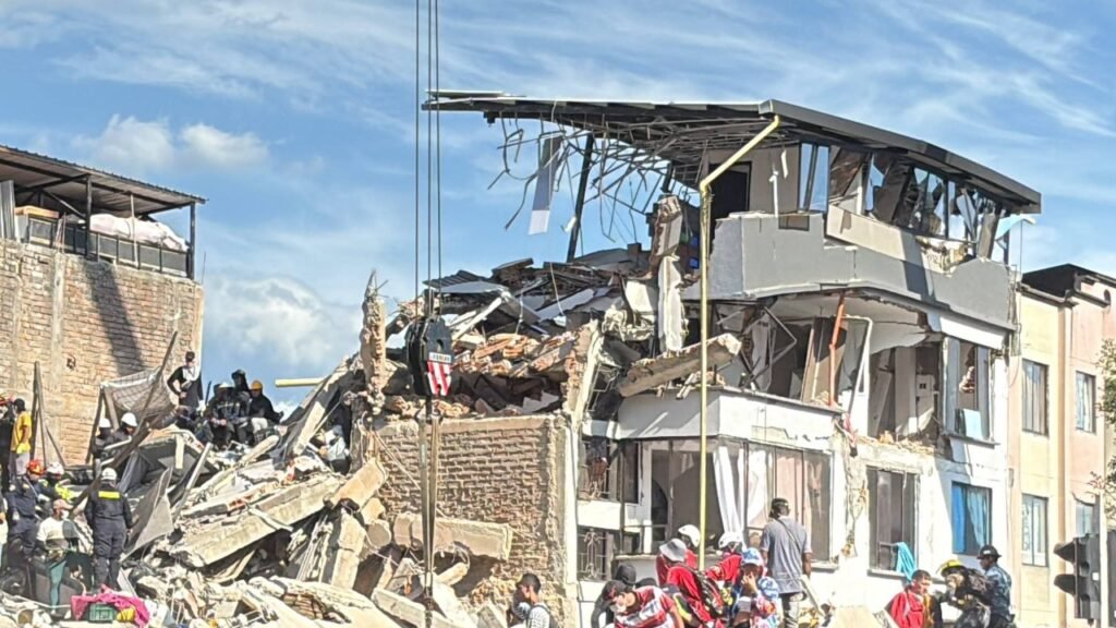
The comparison that matters is with Cali, some 200 kilometres east. Cali’s mayor’s office reported 95 deaths, 949 injuries and 239 people trapped in rubble as of Tuesday morning, along with 32 collapsed structures and fifteen active search-and-rescue points. Emergency teams drawn from the fire service, Civil Defence and the Red Cross had pulled 38 people out alive by Monday evening. Cali is a city of more than two million with hospitals, engineering teams and roads. Choco has a governor and a jungle.
Mayor Alejandro Eder confirmed that national reinforcements were arriving to scale up the technical and logistical response. Nothing comparable is available for the municipalities nearest the epicentre.
The security problem inside the rescue problem
There is a second obstacle that does not appear in seismic reports. Choco is a significant hub for armed groups, and government statistics show a twenty per cent increase in injuries from landmines laid by paramilitary organisations in recent years. The department’s governor told The City Paper Bogota last year that people in many areas are afraid to walk for fear of triggering a mine.
Search and rescue in that environment is not simply slow. It is a different operation, requiring route clearance before dogs and engineers can work, because a collapsed hillside can shift a mine as easily as it shifts a house. Authorities have deployed engineers, rescue workers and search dogs to Choco, but the window in which people are usually found alive, roughly the first forty-eight to seventy-two hours, is closing while that clearance happens.
The International Rescue Committee said its staff near Choco were reporting damage to hospitals and clinics.
“Local communities were already facing armed conflict and high levels of poverty long before the ground began to shake,” said Nicole Kast, the organisation’s director for Colombia, Venezuela and Ecuador, adding that Choco, at the epicentre, is the poorest region in the country.
A president five days into the job
Abelardo de la Espriella was inaugurated on Friday. He declared a state of national disaster on Monday, which gave him emergency powers including the authority to reallocate budgets, and stood up a Unified Command Centre the same day.
Speaking from that centre, he reported 188 people missing, three hospitals collapsed and eighteen more damaged, and thirty-nine schools affected. Earlier figures from the presidency counted 1,575 homes damaged, eighteen health centres, fifty-two educational centres, seventeen community centres and eighteen roads. Later estimates put homes damaged or destroyed at around 5,000, with about 700 people injured nationwide.
“The priority is to try to rescue the people who are still under the rubble,” de la Espriella said, before travelling to Quibdo, Choco’s capital, and then to Cali. He said the government had mobilised its entire military and police apparatus, and promised rental subsidies for people whose homes were damaged.
Writing about the worst-hit city later, he said: “Cali and Valle del Cauca are not alone. The State is present and will continue to act with all its capacity.”
Curfews were imposed in Cali, Armenia and Manizales. Cali deployed additional police and soldiers over concerns about looting. Hospitals in five cities were placed on red alert. The aviation regulator suspended operations at airports serving Pereira, Manizales, Quibdo, Armenia, Cartago and Buenaventura while engineers inspected them for structural damage, which removed the fastest way into the affected region at the moment it was most needed.
The aftershocks are not finished
The Colombian Geological Service counted close to fifty seismic events in the first day, the largest at magnitude 4.8, with epicentres again at San Jose del Palmar at depths of 88 to 99 kilometres.
“These can last for days, weeks, or even months, as energy continues to be released,” the service said, explaining that the process continues until the areas surrounding the rupture zone of the main earthquake are balanced again.
That is the reason governors across western Colombia have told residents to stay outdoors while engineers inspect buildings, and the reason the recovery phase will be slower than the collapse count suggests. Structures weakened on Monday can fail during a magnitude 4.8 aftershock a week later, which is how post-earthquake death tolls keep climbing after the cameras leave.
Depth is the one piece of good news in the seismology. At 99 kilometres this was an intermediate-depth event rather than a shallow one, which spreads the shaking over a wider area but reduces its intensity directly above the rupture. A magnitude 7.4 at ten kilometres under the same towns would have produced a far worse outcome.
Survivors have begun describing what the first shock did. “This community was formed by several blocks of houses. All houses were destroyed. This is a total loss,” Saul Paz, 57, told Reuters, adding that many neighbours had managed to get out before the buildings came down.
The international response
US Secretary of State Marco Rubio said Washington was closely monitoring the disaster and stood ready to support the Colombian government. European Commission President Ursula von der Leyen said the EU’s Copernicus satellite system had been activated for the rescue operation, which provides damage mapping in areas nobody can reach on the ground. Venezuela offered assistance. World Central Kitchen said its network had been activated to deploy emergency food aid.
Neighbouring governments have their own reasons to help quickly. An earthquake in Choco sits on a migration corridor that runs north through the Darien Gap, and a displaced rural population with no housing is the kind of pressure that shows up at other borders within weeks rather than months.
Copernicus imagery is likely to produce the first real assessment of Choco, because it does not require a road. Satellite damage proxy maps were what first revealed the scale of destruction in remote parts of Nepal in 2015 and in Morocco’s High Atlas in 2023, in both cases days before ground teams arrived.
Colombia sits on the Pacific Ring of Fire, and the Choco region lies along the seismic faults that encircle the ocean. The last comparable event near the same epicentre, in February 1995, was a magnitude 6.4 that killed 42 people and caused a few million dollars of damage. Monday’s quake released roughly thirty times more energy.
The 1995 comparison also flags what happens next. Colombia tightened its seismic building code in 1998 and again in 2010, but enforcement has always been weakest where money is shortest. When engineers finally reach San Jose del Palmar, the question they answer will not only be how many died. It will be how much of what fell was built after the rules changed.